
Owatonna topographic map
Interactive map
Click on the map to display elevation.
About this map
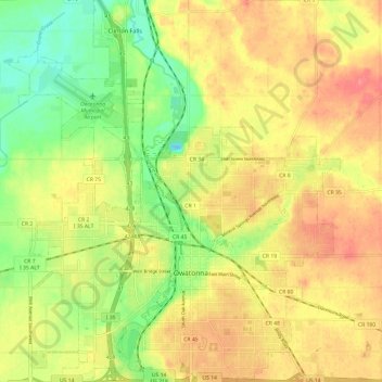
Name: Owatonna topographic map, elevation, terrain.
Location: Owatonna, Steele County, Minnesota, 55060, United States (44.05932 -93.28374 44.14574 -93.17906)
Average elevation: 1,184 ft
Minimum elevation: 1,063 ft
Maximum elevation: 1,286 ft
Other topographic maps
Click on a map to view its topography, its elevation and its terrain.
Gainy Park
United States > Minnesota > Steele County > Owatonna
Gainy Park, Owatonna, Steele County, Minnesota, United States
Average elevation: 1,178 ft
Blooming Prairie
United States > Minnesota > Steele County
Blooming Prairie, Steele County, Minnesota, 55917, United States
Average elevation: 1,289 ft
Summit
United States > Minnesota > Steele County
Summit, Steele County, Minnesota, United States
Average elevation: 1,234 ft
Owatonna
United States > Minnesota > Steele County > Owatonna > Owatonna
Owatonna, Steele County, Minnesota, 55060, United States
Average elevation: 1,191 ft