
Deutschlandsberg topographic map
Interactive map
Click on the map to display elevation.
About this map
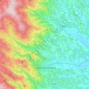
Name: Deutschlandsberg topographic map, elevation, terrain.
Location: Deutschlandsberg, Bezirk Deutschlandsberg, Styria, Austria (46.79310 15.00792 46.92792 15.26645)
Average elevation: 2,014 ft
Minimum elevation: 978 ft
Maximum elevation: 4,783 ft
Other topographic maps
Click on a map to view its topography, its elevation and its terrain.
Hohenfeld
Austria > Styria > Bezirk Deutschlandsberg > Hohenfeld
Hohenfeld, Bezirk Deutschlandsberg, Styria, 8524, Austria
Average elevation: 2,096 ft
Ettendorf bei Stainz
Austria > Styria > Bezirk Deutschlandsberg > Stainz
Ettendorf bei Stainz, Stainz, Bezirk Deutschlandsberg, Styria, 8510, Austria
Average elevation: 1,129 ft