
Nkhata Bay topographic map
Interactive map
Click on the map to display elevation.
About this map
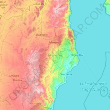
Name: Nkhata Bay topographic map, elevation, terrain.
Location: Nkhata Bay, Northern Region, Malawi, Malawi (-12.24421 33.69185 -10.97275 34.32754)
Average elevation: 3,064 ft
Minimum elevation: 1,545 ft
Maximum elevation: 6,654 ft
Other topographic maps
Click on a map to view its topography, its elevation and its terrain.
Capital Hill
Capital Hill, Lilongwe, Central Region, AREA 32, Malawi
Average elevation: 3,514 ft
Lake Chilwa
Lake Chilwa, Zomba, Southern Region, Malawi
Average elevation: 2,123 ft