
Fianarantsoa topographic map
Interactive map
Click on the map to display elevation.
About this map
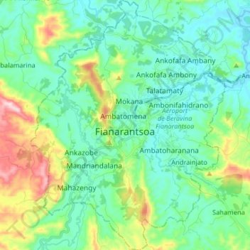
Name: Fianarantsoa topographic map, elevation, terrain.
Average elevation: 3,845 ft
Minimum elevation: 3,491 ft
Maximum elevation: 4,967 ft
It is at an average altitude of 1,200 metres (3,900 ft), and has a population of 191,766.
Other topographic maps
Click on a map to view its topography, its elevation and its terrain.
Fianarantsoa
Madagascar > Haute Matsiatra > District de Fianarantsoa > Fianarantsoa
Fianarantsoa, District de Fianarantsoa, Haute Matsiatra, Province de Fianarantsoa, 301, Madagascar
Average elevation: 3,940 ft