
New Tehri topographic map
Interactive map
Click on the map to display elevation.
About this map
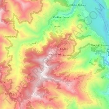
Name: New Tehri topographic map, elevation, terrain.
Average elevation: 4,367 ft
Minimum elevation: 2,001 ft
Maximum elevation: 6,512 ft
Other topographic maps
Click on a map to view its topography, its elevation and its terrain.
Tehri Dam
India > Uttarakhand > Tehri > Bhagirathipuram
Tehri Dam, Bhagirathipuram, Tehri, Tehri Garhwal, Uttarakhand, India
Average elevation: 2,969 ft
ranichauri
India > Uttarakhand > Tehri > Sabli
ranichauri, Sabli, Tehri, Tehri Garhwal, Uttarakhand, 249199, India
Average elevation: 5,295 ft