
Martinsville topographic map
Interactive map
Click on the map to display elevation.
About this map
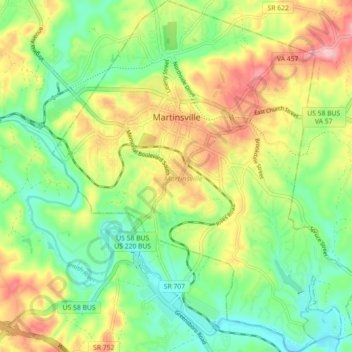
Name: Martinsville topographic map, elevation, terrain.
Location: Martinsville, Martinsville City, Virginia, United States (36.64381 -79.90408 36.71534 -79.82626)
Average elevation: 850 ft
Minimum elevation: 636 ft
Maximum elevation: 1,165 ft
According to the United States Census Bureau, the city has a total area of 11.0 square miles (28.5 km2), of which 11.0 square miles (28.5 km2) is land and 0.1 square miles (0.3 km2) (0.5%) is water. The north side of the city has the highest average elevation. The east side slopes gradually down to the Smith River on the south side. The west side is hilly. Martinsville is located on the southern border of Southern Virginia.