
Spearfish topographic map
Interactive map
Click on the map to display elevation.
About this map
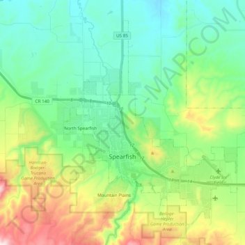
Name: Spearfish topographic map, elevation, terrain.
Location: Spearfish, Lawrence County, South Dakota, United States (44.45282 -103.90541 44.56661 -103.71413)
Average elevation: 3,842 ft
Minimum elevation: 3,228 ft
Maximum elevation: 5,390 ft
Extreme winter maxima in the district are remarkably warm given the latitude and altitude; on January 19, 1921 Spearfish reached a temperature of 79 °F (26 °C), the hottest January temperature in South Dakota on record.
Other topographic maps
Click on a map to view its topography, its elevation and its terrain.
Savoy
United States > South Dakota > Lawrence County
Savoy, Lawrence County, South Dakota, United States
Average elevation: 5,463 ft
Terry Peak
United States > South Dakota > Lawrence County
Terry Peak, Lawrence County, South Dakota, United States
Average elevation: 6,365 ft
Deadwood
United States > South Dakota > Lawrence County
Deadwood, Lawrence County, South Dakota, 57732, United States
Average elevation: 4,957 ft
Cheyenne Crossing
United States > South Dakota > Lawrence County
Cheyenne Crossing, Lawrence County, South Dakota, United States
Average elevation: 5,853 ft
Bridal Veil Falls
United States > South Dakota > Lawrence County
Bridal Veil Falls, Lawrence County, South Dakota, United States
Average elevation: 4,928 ft
Spearfish
United States > South Dakota > Lawrence County > Spearfish
Spearfish, Lawrence County, South Dakota, 57783, United States
Average elevation: 4,236 ft
Lead
United States > South Dakota > Lawrence County
Lead, Lawrence County, South Dakota, United States
Average elevation: 5,266 ft