
Rapid City topographic map
Interactive map
Click on the map to display elevation.
About this map
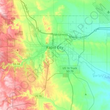
Name: Rapid City topographic map, elevation, terrain.
Location: Rapid City, Pennington County, South Dakota, United States (43.99492 -103.32635 44.13679 -103.03791)
Average elevation: 3,504 ft
Minimum elevation: 2,999 ft
Maximum elevation: 4,560 ft
Rapid City is located at 44°04′34″N 103°13′42″W / 44.076188°N 103.228299°W / 44.076188; -103.228299. The downtown elevation of Rapid City is 3,202 feet (976 m). Rapid City is located in the shadow of Black Elk Peak, which at 7,242 feet (2,207 m), is the highest point east of the Rocky Mountains.
Other topographic maps
Click on a map to view its topography, its elevation and its terrain.
Black Hills
United States > South Dakota > Pennington County
Black Hills, Pennington County, South Dakota, United States
Average elevation: 6,214 ft
Mount Rushmore National Memorial
United States > South Dakota > Pennington County
Mount Rushmore National Memorial, Pennington County, South Dakota, United States
Average elevation: 5,013 ft
Colonial Pine Hills
United States > South Dakota > Pennington County
Colonial Pine Hills, Pennington County, South Dakota, United States
Average elevation: 4,042 ft
Thrall Mountain
United States > South Dakota > Pennington County
Thrall Mountain, Pennington County, South Dakota, United States
Average elevation: 4,567 ft
Scenic
United States > South Dakota > Pennington County
Scenic, Pennington County, South Dakota, 57780, United States
Average elevation: 2,799 ft
Horse Thief Lake
United States > South Dakota > Pennington County
Horse Thief Lake, Pennington County, South Dakota, United States
Average elevation: 5,131 ft
Silver City
United States > South Dakota > Pennington County
Silver City, Pennington County, South Dakota, United States
Average elevation: 4,905 ft
Copper Mountain
United States > South Dakota > Pennington County
Copper Mountain, West Pennington, Pennington County, South Dakota, United States
Average elevation: 6,581 ft
Wall
United States > South Dakota > Pennington County
Wall, Pennington County, South Dakota, 57790, United States
Average elevation: 2,802 ft
Box Elder
United States > South Dakota > Pennington County
Box Elder, Pennington County, South Dakota, United States
Average elevation: 3,176 ft
Hill City
United States > South Dakota > Pennington County
Hill City, Pennington County, South Dakota, United States
Average elevation: 5,154 ft
Warbonnet
United States > South Dakota > Pennington County > Warbonnet
Warbonnet, Pennington County, South Dakota, United States
Average elevation: 3,169 ft
Black Elk Peak
United States > South Dakota > Pennington County
Black Elk Peak, Pennington County, South Dakota, United States
Average elevation: 6,309 ft