
Uvalde topographic map
Interactive map
Click on the map to display elevation.
About this map
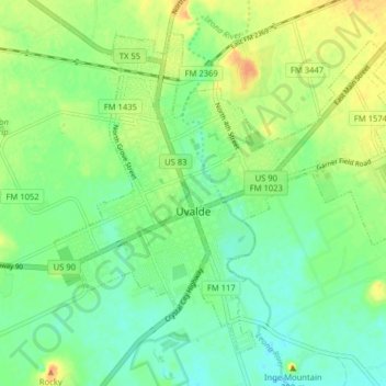
Name: Uvalde topographic map, elevation, terrain.
Location: Uvalde, Uvalde County, Texas, United States (29.18397 -99.81494 29.24162 -99.73534)
Average elevation: 919 ft
Minimum elevation: 873 ft
Maximum elevation: 988 ft
Other topographic maps
Click on a map to view its topography, its elevation and its terrain.
Laguna
United States > Texas > Uvalde County
Laguna, Uvalde County, Texas, United States
Average elevation: 1,171 ft
Montell
United States > Texas > Uvalde County
Montell, Uvalde County, Texas, United States
Average elevation: 1,329 ft
Reagan Wells
United States > Texas > Uvalde County
Reagan Wells, Uvalde County, Texas, United States
Average elevation: 1,585 ft
Uvalde Estates
United States > Texas > Uvalde County
Uvalde Estates, Uvalde County, Texas, United States
Average elevation: 948 ft
Onion Creek
United States > Texas > Uvalde County
Onion Creek, Uvalde County, Texas, United States
Average elevation: 1,339 ft
Blue Mountain
United States > Texas > Uvalde County
Blue Mountain, Uvalde County, Texas, 78870, United States
Average elevation: 1,017 ft
Sabinal
United States > Texas > Uvalde County
Sabinal, Uvalde County, Texas, 78881, United States
Average elevation: 948 ft
Garner State park
United States > Texas > Uvalde County
Garner State park, Uvalde County, Texas, United States
Average elevation: 1,496 ft
Utopia
United States > Texas > Uvalde County
Utopia, Uvalde County, Texas, 78884, United States
Average elevation: 1,388 ft
Concan
United States > Texas > Uvalde County
Concan, Uvalde County, Texas, 78838, United States
Average elevation: 1,375 ft