
Selmer topographic map
Interactive map
Click on the map to display elevation.
About this map
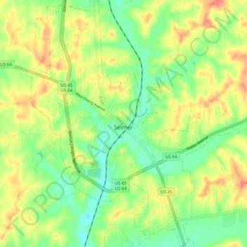
Name: Selmer topographic map, elevation, terrain.
Average elevation: 499 ft
Minimum elevation: 404 ft
Maximum elevation: 614 ft
Other topographic maps
Click on a map to view its topography, its elevation and its terrain.
Leapwood
United States > Tennessee > McNairy County
Leapwood, McNairy County, West Tennessee, Tennessee, United States
Average elevation: 515 ft
Bethel Springs
United States > Tennessee > McNairy County > Bethel Springs
Bethel Springs, McNairy County, West Tennessee, Tennessee, United States
Average elevation: 505 ft
Adamsville
United States > Tennessee > McNairy County
Adamsville, McNairy County, West Tennessee, Tennessee, United States
Average elevation: 469 ft