
Gracehill topographic map
Interactive map
Click on the map to display elevation.
About this map
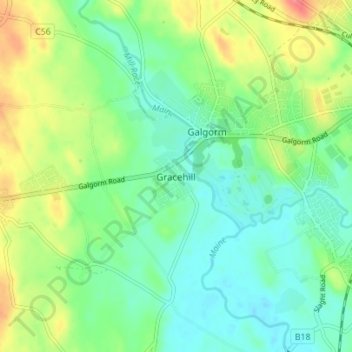
Name: Gracehill topographic map, elevation, terrain.
Average elevation: 177 ft
Minimum elevation: 105 ft
Maximum elevation: 308 ft
Other topographic maps
Click on a map to view its topography, its elevation and its terrain.
Belfast
United Kingdom > Northern Ireland > County Antrim
Belfast, County Antrim, Northern Ireland, BT1 5GS, United Kingdom
Average elevation: 285 ft
Portballintrae
United Kingdom > Northern Ireland > County Antrim
Portballintrae, County Antrim, Northern Ireland, BT57 8RZ, United Kingdom
Average elevation: 89 ft
Portglenone
United Kingdom > Northern Ireland > County Antrim
Portglenone, County Antrim, Northern Ireland, BT44 8AD, United Kingdom
Average elevation: 141 ft
Martinstown
United Kingdom > Northern Ireland > County Antrim
Martinstown, County Antrim, Northern Ireland, BT43 6QH, United Kingdom
Average elevation: 571 ft
Tildarg
United Kingdom > Northern Ireland > County Antrim
Tildarg, County Antrim, Northern Ireland, BT39 9ZW, United Kingdom
Average elevation: 669 ft
Nutts Corner
United Kingdom > Northern Ireland > County Antrim
Nutts Corner, County Antrim, Northern Ireland, BT29 4SR, United Kingdom
Average elevation: 344 ft
Ballygomartin
United Kingdom > Northern Ireland > County Antrim > Belfast
Ballygomartin, Ligoniel, Belfast, County Antrim, Northern Ireland, United Kingdom
Average elevation: 846 ft
Aghagallon
United Kingdom > Northern Ireland > County Antrim
Aghagallon, County Antrim, Northern Ireland, BT67 0AR, United Kingdom
Average elevation: 102 ft
Ballymena
United Kingdom > Northern Ireland > County Antrim
Ballymena, County Antrim, Northern Ireland, BT43 6DT, United Kingdom
Average elevation: 243 ft
Lisburn
United Kingdom > Northern Ireland > County Antrim
Lisburn, County Antrim, Northern Ireland, BT28 1BJ, United Kingdom
Average elevation: 302 ft
Whitehead
United Kingdom > Northern Ireland > County Antrim
Whitehead, County Antrim, Northern Ireland, BT38 9RU, United Kingdom
Average elevation: 121 ft
Botanic Gardens
United Kingdom > Northern Ireland > County Antrim > Belfast
Botanic Gardens, Queen's Quarter, Belfast, County Antrim, Northern Ireland, United Kingdom
Average elevation: 49 ft
Carrickfergus
United Kingdom > Northern Ireland > County Antrim
Carrickfergus, County Antrim, Northern Ireland, BT38 7AN, United Kingdom
Average elevation: 161 ft
Lough Neagh
United Kingdom > Northern Ireland > County Antrim
Lough Neagh, County Antrim, Ulster, Northern Ireland, United Kingdom
Average elevation: 95 ft
Upper Ballinderry
United Kingdom > Northern Ireland > County Antrim
Upper Ballinderry, County Antrim, Ulster, Northern Ireland, BT28 2LW, United Kingdom
Average elevation: 243 ft
Ballyclare
United Kingdom > Northern Ireland > County Antrim
Ballyclare, County Antrim, Northern Ireland, BT39 9BB, United Kingdom
Average elevation: 394 ft
Lisnacrogher
United Kingdom > Northern Ireland > County Antrim
Lisnacrogher, County Antrim, Ulster, Northern Ireland, United Kingdom
Average elevation: 354 ft
Ballymoney
United Kingdom > Northern Ireland > County Antrim
Ballymoney, County Antrim, Northern Ireland, BT53 6AY, United Kingdom
Average elevation: 167 ft
Old Mill
United Kingdom > Northern Ireland > County Antrim > Ballygally
Old Mill, Ballygally, County Antrim, Ulster, Northern Ireland, BT40 2RX, United Kingdom
Average elevation: 154 ft
Straid
United Kingdom > Northern Ireland > County Antrim
Straid, County Antrim, Ulster, Northern Ireland, BT39 9NQ, United Kingdom
Average elevation: 581 ft
Ballintoy
United Kingdom > Northern Ireland > County Antrim
Ballintoy, County Antrim, Ulster, Northern Ireland, BT54 6LX, United Kingdom
Average elevation: 240 ft
Maghaberry
United Kingdom > Northern Ireland > County Antrim
Maghaberry, County Antrim, Ulster, Northern Ireland, BT67 0JE, United Kingdom
Average elevation: 213 ft
Ballycastle
United Kingdom > Northern Ireland > County Antrim
Ballycastle, County Antrim, Northern Ireland, BT54 6AW, United Kingdom
Average elevation: 259 ft
Cullybackey
United Kingdom > Northern Ireland > County Antrim
Cullybackey, County Antrim, Ulster, Northern Ireland, BT42 1NH, United Kingdom
Average elevation: 302 ft
Larne
United Kingdom > Northern Ireland > County Antrim
Larne, County Antrim, Northern Ireland, BT40 1JS, United Kingdom
Average elevation: 177 ft
Armoy
United Kingdom > Northern Ireland > County Antrim
Armoy, County Antrim, Ulster, Northern Ireland, BT53 8RH, United Kingdom
Average elevation: 335 ft
Dunadry
United Kingdom > Northern Ireland > County Antrim
Dunadry, County Antrim, Ulster, Northern Ireland, BT41 4QT, United Kingdom
Average elevation: 217 ft
Cavehill
United Kingdom > Northern Ireland > County Antrim > Belfast
Cavehill, Belfast, County Antrim, Northern Ireland, BT36 7PN, United Kingdom
Average elevation: 617 ft
Portrush
United Kingdom > Northern Ireland > County Antrim
Portrush, County Antrim, Northern Ireland, BT56 8BN, United Kingdom
Average elevation: 75 ft
Kinbane Castle
United Kingdom > Northern Ireland > County Antrim > Ballycastle
Kinbane Castle, Whitepark Road, Ballycastle, County Antrim, Northern Ireland, BT54 6GA, United Kingdom
Average elevation: 121 ft
Dunloy
United Kingdom > Northern Ireland > County Antrim
Dunloy, County Antrim, Northern Ireland, BT44 9EF, United Kingdom
Average elevation: 420 ft
Cargan
United Kingdom > Northern Ireland > County Antrim > Cargan
Cargan, County Antrim, Ulster, Northern Ireland, BT43 6RB, United Kingdom
Average elevation: 807 ft
Kells
United Kingdom > Northern Ireland > County Antrim
Kells, County Antrim, Ulster, Northern Ireland, BT42 3LS, United Kingdom
Average elevation: 295 ft
McArt's Fort
United Kingdom > Northern Ireland > County Antrim > Belfast
McArt's Fort, Ben Madigan Heights, Whitewell, Belfast, County Antrim, Northern Ireland, BT36 7RW, United Kingdom
Average elevation: 541 ft
Randalstown
United Kingdom > Northern Ireland > County Antrim
Randalstown, County Antrim, Northern Ireland, BT41 3AD, United Kingdom
Average elevation: 187 ft
Glengormley
United Kingdom > Northern Ireland > County Antrim > Newtownabbey
Glengormley, Newtownabbey, County Antrim, Northern Ireland, United Kingdom
Average elevation: 505 ft
Islandmagee
United Kingdom > Northern Ireland > County Antrim
Islandmagee, County Antrim, Northern Ireland, BT40 3SH, United Kingdom
Average elevation: 75 ft
Magheragall
United Kingdom > Northern Ireland > County Antrim > Lisburn
Magheragall, Lisburn, County Antrim, Northern Ireland, BT28 2XF, United Kingdom
Average elevation: 171 ft
Antrim
United Kingdom > Northern Ireland > County Antrim
Antrim, County Antrim, Northern Ireland, BT41 4AR, United Kingdom
Average elevation: 164 ft
Kilwaughter
United Kingdom > Northern Ireland > County Antrim > Kilwaughter
Kilwaughter, County Antrim, Northern Ireland, BT40 2PT, United Kingdom
Average elevation: 528 ft
Dunmurry
United Kingdom > Northern Ireland > County Antrim > Lisburn
Dunmurry, Lisburn, County Antrim, Ulster, Northern Ireland, United Kingdom
Average elevation: 125 ft
Rasharkin
United Kingdom > Northern Ireland > County Antrim
Rasharkin, County Antrim, Northern Ireland, BT44 8RX, United Kingdom
Average elevation: 292 ft
Dervock
United Kingdom > Northern Ireland > County Antrim > Dervock
Dervock, County Antrim, Northern Ireland, BT53 8BT, United Kingdom
Average elevation: 144 ft
Tamybuck
United Kingdom > Northern Ireland > County Antrim > Aughafatten
Tamybuck, Aughafatten, County Antrim, Northern Ireland, BT42 4LP, United Kingdom
Average elevation: 561 ft
Cushendun
United Kingdom > Northern Ireland > County Antrim
Cushendun, County Antrim, Ulster, Northern Ireland, BT44 0PH, United Kingdom
Average elevation: 194 ft
Edenderry
United Kingdom > Northern Ireland > County Antrim > Belfast
Edenderry, Woodvale, Belfast, County Antrim, Northern Ireland, United Kingdom
Average elevation: 164 ft
Bushmills
United Kingdom > Northern Ireland > County Antrim
Bushmills, County Antrim, Northern Ireland, BT57 8QB, United Kingdom
Average elevation: 138 ft
Carnlough
United Kingdom > Northern Ireland > County Antrim
Carnlough, County Antrim, Ulster, Northern Ireland, BT44 0EU, United Kingdom
Average elevation: 253 ft
Ahoghill
United Kingdom > Northern Ireland > County Antrim
Ahoghill, County Antrim, Northern Ireland, BT42 1JZ, United Kingdom
Average elevation: 276 ft
Newtownabbey
United Kingdom > Northern Ireland > County Antrim
Newtownabbey, County Antrim, Northern Ireland, BT36 6UN, United Kingdom
Average elevation: 328 ft