
Manhattan topographic map
Interactive map
Click on the map to display elevation.
About this map
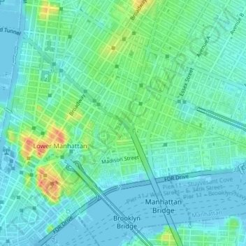
Name: Manhattan topographic map, elevation, terrain.
Average elevation: 39 ft
Minimum elevation: -23 ft
Maximum elevation: 154 ft
Other topographic maps
Click on a map to view its topography, its elevation and its terrain.
Prospect Park
USA > New York > New York City
Prospect Park, Windsor Terrace, Brooklyn, Kings County, New York City, New York, USA
Average elevation: 112 ft
East River
USA > New York > New York City
East River, New York County, New York City, New York, 10044, USA
Average elevation: 49 ft
Midtown South
USA > New York > New York City
Midtown South, Manhattan, Manhattan Community Board 5, New York County, New York City, New York, 10118, USA
Average elevation: 66 ft
Meatpacking District
USA > New York > New York City
Meatpacking District, Manhattan, Manhattan Community Board 2, New York County, New York City, New York, 100014, USA
Average elevation: 30 ft
Midtown East
USA > New York > New York City
Midtown East, Manhattan, Manhattan Community Board 5, New York County, New York City, New York, USA
Average elevation: 72 ft