
Salinas topographic map
Interactive map
Click on the map to display elevation.
About this map
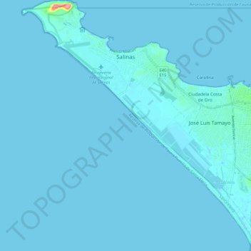
Name: Salinas topographic map, elevation, terrain.
Location: Salinas, Santa Elena Province, 241550, Ecuador (-2.29052 -81.01137 -2.18387 -80.91074)
Average elevation: 7 ft
Minimum elevation: -7 ft
Maximum elevation: 295 ft
Other topographic maps
Click on a map to view its topography, its elevation and its terrain.
Chipipe
Ecuador > Santa Elena Province > Salinas > Salinas
Chipipe, Salinas, Santa Elena Province, Ecuador
Average elevation: 23 ft