
Bartlesville topographic map
Interactive map
Click on the map to display elevation.
About this map
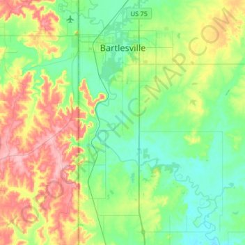
Name: Bartlesville topographic map, elevation, terrain.
Location: Bartlesville, Washington County, Oklahoma, United States (36.57206 -96.01276 36.78339 -95.88979)
Average elevation: 758 ft
Minimum elevation: 620 ft
Maximum elevation: 1,040 ft
Other topographic maps
Click on a map to view its topography, its elevation and its terrain.
Dewey
United States > Oklahoma > Washington County
Dewey, Washington County, Oklahoma, 74029, United States
Average elevation: 692 ft
Bartlesville
United States > Oklahoma > Washington County > Bartlesville
Bartlesville, Washington County, Oklahoma, 74003-4330, United States
Average elevation: 791 ft