
Afrin topographic map
Interactive map
Click on the map to display elevation.
About this map
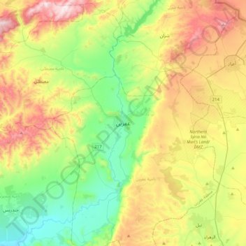
Name: Afrin topographic map, elevation, terrain.
Average elevation: 1,480 ft
Minimum elevation: 466 ft
Maximum elevation: 3,156 ft
In August 2015, the University of Afrin started teaching, with initial programs in literature, engineering and economics, including institutes for medicine, topographic engineering, music and theater, business administration and the Kurdish language. In January 2018, the university closed due to Operation Olive Branch and did not open after the city was captured by Turkish-backed forces. In October 2019, Turkey announced that the University of Gaziantep will open a Faculty of Education in Afrin. In February 2019, it was reported that Turkey was assuming control over the educational matters in Afrin, providing training to teachers and turkifiying the curriculum taught in the schools. BBC also reported that Turkey enabled the establishment of a religious İmam Hatip school in Afrin.
Other topographic maps
Click on a map to view its topography, its elevation and its terrain.
Tall as Sab`in
Syria > Aleppo Governorate > تل سبعن
Tall as Sab`in, تل سبعن, Eastern Kuweires Subdistrict, Deir Hafer ِِDistrict, Aleppo Governorate, Syria
Average elevation: 1,083 ft
Tall al-Maqla
Syria > Aleppo Governorate > Aleppo
Tall al-Maqla, Aleppo, Mount Simeon Subdistrict, Mount Simeon District, Aleppo Governorate, Syria
Average elevation: 1,447 ft
Ad-Dabashiyah
Ad-Dabashiyah, Al-Jalabiyah (Chalabi) Subdistrict, Ayn Al-Arab (Kobani) District, Aleppo Governorate, Syria
Average elevation: 1,234 ft
Zahraa
Zahraa, Nubl Subdistrict, Azaz District, Aleppo Governorate, Syria
Average elevation: 1,437 ft
Khuraybah
Khuraybah, Jindires Subdistrict, Afrin District, Aleppo Governorate, Syria
Average elevation: 856 ft
Abu Shaylam
Abu Shaylam, Mount Simeon Subdistrict, Mount Simeon District, Aleppo Governorate, Syria
Average elevation: 1,115 ft
Al Hadath
Al Hadath, Al-Bab Subdistrict, al-Bab District, Aleppo Governorate, Syria
Average elevation: 1,598 ft
Mount Simeon Subdistrict
Mount Simeon Subdistrict, Mount Simeon District, Aleppo Governorate, Syria
Average elevation: 1,345 ft
`Arbid
`Arbid, Eastern Kuweires Subdistrict, Deir Hafer ِِDistrict, Aleppo Governorate, Syria
Average elevation: 1,204 ft
A`zaz
Syria > Aleppo Governorate > A`zaz
A`zaz, Azaz Subdistrict, Azaz District, Aleppo Governorate, Syria
Average elevation: 1,834 ft
Ma`arrat al `Atiq
Syria > Aleppo Governorate > Ma`arrat al `Atiq
Ma`arrat al `Atiq, Haritan Subdistrict, Mount Simeon District, Aleppo Governorate, Syria
Average elevation: 1,325 ft
Ster
Syria > Aleppo Governorate > Ster
Ster, Afrin Subdistrict, Afrin District, Aleppo Governorate, Syria
Average elevation: 938 ft
Balat
Syria > Aleppo Governorate > Balat
Balat, Al-Safirah Subdistrict, Al-Safirah District, Aleppo Governorate, Syria
Average elevation: 1,181 ft
Rayyan
Syria > Aleppo Governorate > Rayyan
Rayyan, Aleppo Governorate, Syria
Average elevation: 1,148 ft
Aleppo
Aleppo, Mount Simeon Subdistrict, Mount Simeon District, Aleppo Governorate, Syria
Average elevation: 1,355 ft
Azaz District
Azaz District, Aleppo Governorate, Syria
Average elevation: 1,621 ft
Azraq
Syria > Aleppo Governorate > Azraq
Azraq, Al-Bab Subdistrict, al-Bab District, Aleppo Governorate, Syria
Average elevation: 1,732 ft
Manbij
Manbij, Manbij Subdistrict, Manbij District, Aleppo Governorate, Syria
Average elevation: 1,512 ft
Al-Bab
Al-Bab, Al-Bab Subdistrict, al-Bab District, Aleppo Governorate, Syria
Average elevation: 1,509 ft
Tall Butnan
Syria > Aleppo Governorate > Al-Bab
Tall Butnan, Al-Bab, Al-Bab Subdistrict, al-Bab District, Aleppo Governorate, Syria
Average elevation: 1,473 ft
Kobani
Kobani, Ayn Al-Arab (Kobani) Subistrict, Ayn Al-Arab (Kobani) District, Aleppo Governorate, Syria
Average elevation: 1,713 ft
Saharij
Saharij, Sarin Subdistrict, Ayn Al-Arab (Kobani) District, Aleppo Governorate, Syria
Average elevation: 1,486 ft