
Parroquia Chacao topographic map
Interactive map
Click on the map to display elevation.
About this map
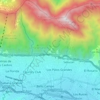
Name: Parroquia Chacao topographic map, elevation, terrain.
Average elevation: 4,498 ft
Minimum elevation: 2,730 ft
Maximum elevation: 8,563 ft
Other topographic maps
Click on a map to view its topography, its elevation and its terrain.
Silla de Caracas
Venezuela > Miranda > Parroquia Chacao
Silla de Caracas, Parroquia Chacao, Municipio Chacao, Miranda, Región Capital, 1062A, Venezuela
Average elevation: 6,647 ft