
Cantón Osa topographic map
Interactive map
Click on the map to display elevation.
About this map
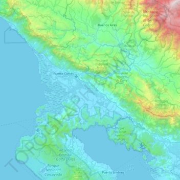
Name: Cantón Osa topographic map, elevation, terrain.
Location: Cantón Osa, Provincia Puntarenas, Costa Rica (8.50167 -83.89556 9.28100 -83.16274)
Average elevation: 1,224 ft
Minimum elevation: -3 ft
Maximum elevation: 11,437 ft
Osa has an area of 1,930.24 km² and a mean elevation of 24 metres.
Other topographic maps
Click on a map to view its topography, its elevation and its terrain.
Dominical
Costa Rica > Provincia Puntarenas > Cantón Osa > Bahía Ballena > Dominical
Dominical, Bahía Ballena, Cantón Osa, Provincia Puntarenas, 60504, Costa Rica
Average elevation: 220 ft