
Elgoibar topographic map
Interactive map
Click on the map to display elevation.
About this map
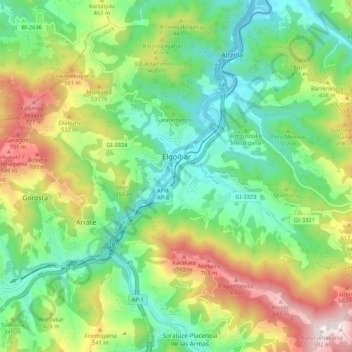
Name: Elgoibar topographic map, elevation, terrain.
Average elevation: 1,053 ft
Minimum elevation: 46 ft
Maximum elevation: 2,920 ft
Other topographic maps
Click on a map to view its topography, its elevation and its terrain.
Mendaro
Spain > Autonomous Community of the Basque Country > Debabarrena > Mendaro
Mendaro, Debabarrena, Gipuzkoa, Autonomous Community of the Basque Country, 20850, Spain
Average elevation: 951 ft