
Oshkosh topographic map
Interactive map
Click on the map to display elevation.
About this map
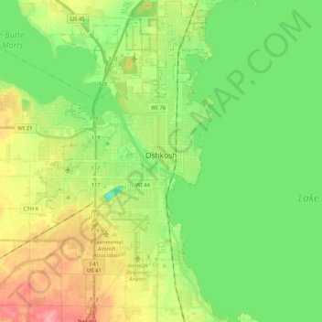
Name: Oshkosh topographic map, elevation, terrain.
Location: Oshkosh, Winnebago County, Wisconsin, United States (43.94504 -88.62270 44.09057 -88.50787)
Average elevation: 771 ft
Minimum elevation: 666 ft
Maximum elevation: 935 ft
Other topographic maps
Click on a map to view its topography, its elevation and its terrain.
Fox Crossing
United States > Wisconsin > Winnebago County
Fox Crossing, Winnebago County, Wisconsin, United States
Average elevation: 781 ft
Winneconne
United States > Wisconsin > Winnebago County
Winneconne, Winnebago County, Wisconsin, 54986, United States
Average elevation: 755 ft
Larsen
United States > Wisconsin > Winnebago County
Larsen, Town of Clayton, Winnebago County, Wisconsin, United States
Average elevation: 781 ft
Lake Poygan
United States > Wisconsin > Winnebago County
Lake Poygan, Town of Poygan, Winnebago County, Wisconsin, United States
Average elevation: 755 ft
Oshkosh
United States > Wisconsin > Winnebago County > Oshkosh
Oshkosh, Winnebago County, Wisconsin, 54903, United States
Average elevation: 784 ft
Neenah
United States > Wisconsin > Winnebago County
Neenah, Winnebago County, Wisconsin, 54956, United States
Average elevation: 755 ft