
Billington and Langho topographic map
Interactive map
Click on the map to display elevation.
About this map
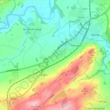
Name: Billington and Langho topographic map, elevation, terrain.
Average elevation: 328 ft
Minimum elevation: 92 ft
Maximum elevation: 778 ft
Other topographic maps
Click on a map to view its topography, its elevation and its terrain.
Clitheroe
United Kingdom > England > Ribble Valley > Clitheroe
Clitheroe, Lancashire, North West England, England, BB7 2BT, United Kingdom
Average elevation: 410 ft
Bolton-by-Bowland
United Kingdom > England > Ribble Valley
Bolton-by-Bowland, Ribble Valley, Lancashire, North West England, England, United Kingdom
Average elevation: 633 ft
Bolton by Bowland
United Kingdom > England > Ribble Valley > Bolton by Bowland
Bolton by Bowland, Ribble Valley, Lancashire, North West England, England, BB7 4NQ, United Kingdom
Average elevation: 436 ft
Simonstone
United Kingdom > England > Ribble Valley > Simonstone
Simonstone, Ribble Valley, Lancashire, North West England, England, United Kingdom
Average elevation: 443 ft
Brennand River
United Kingdom > England > Ribble Valley
Brennand River, Ribble Valley, Lancashire, North West England, England, BB7 3BL, United Kingdom
Average elevation: 1,070 ft
Whitendale River
United Kingdom > England > Ribble Valley
Whitendale River, Ribble Valley, Lancashire, North West England, England, BB7 3BL, United Kingdom
Average elevation: 1,168 ft
Aighton, Bailey and Chaigley
United Kingdom > England > Ribble Valley
Aighton, Bailey and Chaigley, Ribble Valley, Lancashire, North West England, England, United Kingdom
Average elevation: 400 ft
River Dunsop
United Kingdom > England > Ribble Valley
River Dunsop, Ribble Valley, Lancashire, North West England, England, BB7 3BD, United Kingdom
Average elevation: 801 ft