
Olneyville topographic map
Interactive map
Click on the map to display elevation.
About this map
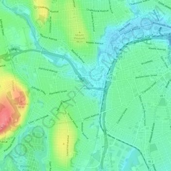
Name: Olneyville topographic map, elevation, terrain.
Average elevation: 79 ft
Minimum elevation: -3 ft
Maximum elevation: 272 ft
Other topographic maps
Click on a map to view its topography, its elevation and its terrain.
Roosevelt Lake
United States > Rhode Island > Providence County > Providence
Roosevelt Lake, Providence, Providence County, Rhode Island, United States
Average elevation: 39 ft
Cunliff Pond Dam
United States > Rhode Island > Providence County > Providence
Cunliff Pond Dam, Providence, Providence County, Rhode Island, 02905, United States
Average elevation: 30 ft
Providence River
United States > Rhode Island > Providence County > Providence
Providence River, Providence, Providence County, Rhode Island, 02903, United States
Average elevation: 30 ft