
Boonville topographic map
Interactive map
Click on the map to display elevation.
About this map
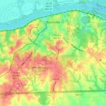
Name: Boonville topographic map, elevation, terrain.
Location: Boonville, Cooper County, Missouri, 65233, United States (38.93191 -92.79316 38.98419 -92.71783)
Average elevation: 686 ft
Minimum elevation: 571 ft
Maximum elevation: 814 ft
Other topographic maps
Click on a map to view its topography, its elevation and its terrain.
Pilot Grove
United States > Missouri > Cooper County
Pilot Grove, Cooper County, Missouri, United States
Average elevation: 804 ft
Boonville
United States > Missouri > Cooper County > Boonville > Boonville
Boonville, Cooper County, Missouri, 65233, United States
Average elevation: 650 ft
Speed
United States > Missouri > Cooper County > Speed
Speed, Cooper County, Missouri, United States
Average elevation: 761 ft