
Weatherford topographic map
Interactive map
Click on the map to display elevation.
About this map
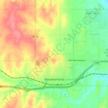
Name: Weatherford topographic map, elevation, terrain.
Location: Weatherford, Custer County, Oklahoma, 73096, United States (35.51512 -98.72516 35.56602 -98.64992)
Average elevation: 1,686 ft
Minimum elevation: 1,549 ft
Maximum elevation: 1,844 ft
Weatherford is located at 35°32′18″N 98°41′14″W / 35.53833°N 98.68722°W / 35.53833; -98.68722 (35.5384097, -98.6872467). The elevation is 1,634 feet (498 m). According to the United States Census Bureau, the city has a total area of 7.05 square miles (18.3 km2), all land.
Other topographic maps
Click on a map to view its topography, its elevation and its terrain.
Moorewood
United States > Oklahoma > Custer County
Moorewood, Custer County, Oklahoma, United States
Average elevation: 1,827 ft
Thomas
United States > Oklahoma > Custer County
Thomas, Custer County, Oklahoma, 73669, United States
Average elevation: 1,755 ft
Arapaho
United States > Oklahoma > Custer County
Arapaho, Custer County, Oklahoma, 73620, United States
Average elevation: 1,621 ft
Clinton
United States > Oklahoma > Custer County
Clinton, Custer County, Oklahoma, 73601, United States
Average elevation: 1,578 ft
Weatherford
United States > Oklahoma > Custer County > Weatherford > Weatherford
Weatherford, Custer County, Oklahoma, 73096, United States
Average elevation: 1,696 ft