
Platteville topographic map
Interactive map
Click on the map to display elevation.
About this map
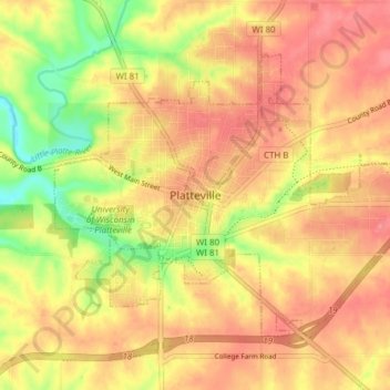
Name: Platteville topographic map, elevation, terrain.
Location: Platteville, Grant County, Wisconsin, 53818, United States (42.71397 -90.50631 42.75469 -90.42960)
Average elevation: 968 ft
Minimum elevation: 797 ft
Maximum elevation: 1,073 ft
Platteville is the largest city in Grant County in southwestern Wisconsin. The population was 11,836 at the 2020 census, up from 11,224 at the 2010 census. Much of this growth is likely due to the enrollment increase of the University of Wisconsin–Platteville. It is the principal city of the Platteville Micropolitan Statistical area, which has an estimated population of 49,681. Platteville is located atop the greater Platte River valley in the southern Driftless Region of Wisconsin, an area known for its karst topography and rolling hills.
Other topographic maps
Click on a map to view its topography, its elevation and its terrain.
Montfort
United States > Wisconsin > Grant County
Montfort, Grant County, Wisconsin, United States
Average elevation: 1,142 ft
Bagley
United States > Wisconsin > Grant County
Bagley, Grant County, Wisconsin, United States
Average elevation: 679 ft
Mount Hope
United States > Wisconsin > Grant County
Mount Hope, Grant County, Wisconsin, United States
Average elevation: 1,145 ft
Village of Woodman
United States > Wisconsin > Grant County
Village of Woodman, Grant County, Wisconsin, United States
Average elevation: 774 ft
Town of Glen Haven
United States > Wisconsin > Grant County
Town of Glen Haven, Grant County, Wisconsin, 53810, United States
Average elevation: 860 ft
Kieler
United States > Wisconsin > Grant County
Kieler, Town of Jamestown, Grant County, Wisconsin, 53812, United States
Average elevation: 902 ft
Hazel Green
United States > Wisconsin > Grant County
Hazel Green, Grant County, Wisconsin, United States
Average elevation: 912 ft
Bloomington
United States > Wisconsin > Grant County
Bloomington, Grant County, Wisconsin, United States
Average elevation: 984 ft
Cuba City
United States > Wisconsin > Grant County
Cuba City, Grant County, Wisconsin, United States
Average elevation: 988 ft
Potosi
United States > Wisconsin > Grant County
Potosi, Grant County, Wisconsin, United States
Average elevation: 866 ft
Patch Grove
United States > Wisconsin > Grant County
Patch Grove, Grant County, Wisconsin, United States
Average elevation: 1,102 ft
Tennyson
United States > Wisconsin > Grant County
Tennyson, Grant County, Wisconsin, United States
Average elevation: 925 ft
Sandy Hook
United States > Wisconsin > Grant County
Sandy Hook, Town of Jamestown, Grant County, Wisconsin, 53812, United States
Average elevation: 804 ft
Town of Beetown
United States > Wisconsin > Grant County
Town of Beetown, Grant County, Wisconsin, 53802, United States
Average elevation: 922 ft
Sinsinawa
United States > Wisconsin > Grant County
Sinsinawa, Town of Hazel Green, Grant County, Wisconsin, United States
Average elevation: 909 ft
Stitzer
United States > Wisconsin > Grant County
Stitzer, Town of Liberty, Grant County, Wisconsin, 53825, United States
Average elevation: 1,086 ft
Van Buren
United States > Wisconsin > Grant County > Potosi
Van Buren, Potosi, Grant County, Wisconsin, 53820, United States
Average elevation: 794 ft
Fennimore
United States > Wisconsin > Grant County
Fennimore, Grant County, Wisconsin, United States
Average elevation: 1,158 ft
Mississippi River
United States > Wisconsin > Grant County > Dubuque
Mississippi River, Dubuque, Town of Jamestown, Grant County, Wisconsin, 52001, United States
Average elevation: 666 ft
Town of Paris
United States > Wisconsin > Grant County
Town of Paris, Grant County, Wisconsin, United States
Average elevation: 827 ft
Dickeyville
United States > Wisconsin > Grant County
Dickeyville, Grant County, Wisconsin, 53808, United States
Average elevation: 902 ft
Lancaster
United States > Wisconsin > Grant County
Lancaster, Grant County, Wisconsin, 53813, United States
Average elevation: 1,070 ft
Livingston
United States > Wisconsin > Grant County
Livingston, Grant County, Wisconsin, United States
Average elevation: 1,132 ft
Town of Wyalusing
United States > Wisconsin > Grant County
Town of Wyalusing, Grant County, Wisconsin, 53801, United States
Average elevation: 866 ft
Blue River
United States > Wisconsin > Grant County
Blue River, Grant County, Wisconsin, United States
Average elevation: 732 ft
Boscobel
United States > Wisconsin > Grant County
Boscobel, Grant County, Wisconsin, United States
Average elevation: 732 ft
Cassville
United States > Wisconsin > Grant County
Cassville, Grant County, Wisconsin, United States
Average elevation: 728 ft
Muscoda
United States > Wisconsin > Grant County
Muscoda, Grant County, Wisconsin, United States
Average elevation: 689 ft