
Ruchstock topographic map
Interactive map
Click on the map to display elevation.
About this map
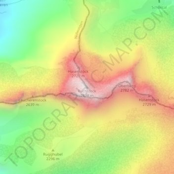
Name: Ruchstock topographic map, elevation, terrain.
Location: Ruchstock, Isenthal, Uri, 6461, Svizzera (46.85631 8.47084 46.85641 8.47094)
Average elevation: 7,575 ft
Minimum elevation: 5,994 ft
Maximum elevation: 9,222 ft
Other topographic maps
Click on a map to view its topography, its elevation and its terrain.
Engelberger Rotstock
Engelberger Rotstock, Isenthal, Uri, 6461, Svizzera
Average elevation: 7,792 ft
Brunnistock
Brunnistock, Isenthal, Uri, 6461, Svizzera
Average elevation: 7,566 ft