
Vaihingen topographic map
Interactive map
Click on the map to display elevation.
About this map
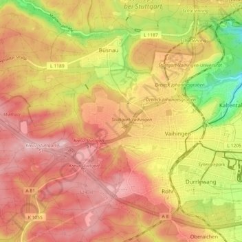
Name: Vaihingen topographic map, elevation, terrain.
Location: Vaihingen, Stuttgart, Baden-Württemberg, Germany (48.71051 9.03860 48.75838 9.12845)
Average elevation: 1,496 ft
Minimum elevation: 1,089 ft
Maximum elevation: 1,752 ft
Other topographic maps
Click on a map to view its topography, its elevation and its terrain.
Untertürkheim
Germany > Baden-Württemberg > Stuttgart
Untertürkheim, Stuttgart, Baden-Württemberg, 70327, Germany
Average elevation: 856 ft