
Penrith topographic map
Interactive map
Click on the map to display elevation.
About this map
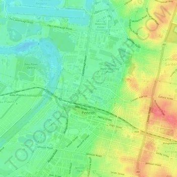
Name: Penrith topographic map, elevation, terrain.
Average elevation: 112 ft
Minimum elevation: 26 ft
Maximum elevation: 240 ft
Penrith is a town in New South Wales, Australia, located in Greater Western Sydney, 55 kilometres (31 mi) west of the Sydney central business district on the banks of the Nepean River, on the outskirts of the Cumberland Plain. Its elevation is 32 metres (105 ft).
Other topographic maps
Click on a map to view its topography, its elevation and its terrain.
Sydney International Regatta Centre
Australia > New South Wales > Sydney > Penrith
Sydney International Regatta Centre, Castlereagh, Penrith, Sydney, Penrith City Council, New South Wales, 2749, Australia
Average elevation: 62 ft
South Penrith
Australia > New South Wales > Sydney > Penrith
South Penrith, Penrith, Sydney, Penrith City Council, New South Wales, 2750, Australia
Average elevation: 157 ft