
Winterberg topographic map
Interactive map
Click on the map to display elevation.
About this map
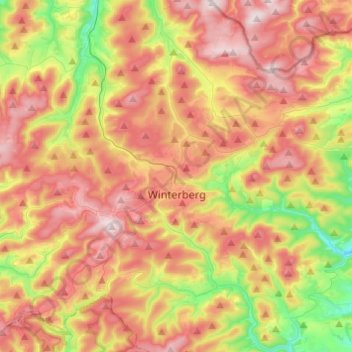
Name: Winterberg topographic map, elevation, terrain.
Average elevation: 2,057 ft
Minimum elevation: 1,280 ft
Maximum elevation: 2,769 ft
Other topographic maps
Click on a map to view its topography, its elevation and its terrain.
Bestwig
Germany > North Rhine-Westphalia > Hochsauerlandkreis
Bestwig, Hochsauerlandkreis, North Rhine-Westphalia, 59909, Germany
Average elevation: 1,529 ft
Marsberg
Germany > North Rhine-Westphalia > Hochsauerlandkreis > Marsberg
Marsberg, Hochsauerlandkreis, North Rhine-Westphalia, 34431, Germany
Average elevation: 1,188 ft
Winterberg
Germany > North Rhine-Westphalia > Hochsauerlandkreis > Winterberg > Winterberg
Winterberg, Hochsauerlandkreis, North Rhine-Westphalia, 59955, Germany
Average elevation: 2,126 ft
Meschede
Germany > North Rhine-Westphalia > Hochsauerlandkreis
Meschede, Hochsauerlandkreis, North Rhine-Westphalia, 59872, Germany
Average elevation: 1,368 ft