
Rutledge topographic map
Interactive map
Click on the map to display elevation.
About this map
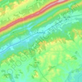
Name: Rutledge topographic map, elevation, terrain.
Average elevation: 1,329 ft
Minimum elevation: 938 ft
Maximum elevation: 2,438 ft
Other topographic maps
Click on a map to view its topography, its elevation and its terrain.
Blaine
United States > Tennessee > Grainger County
Blaine, Grainger County, East Tennessee, Tennessee, 37709, United States
Average elevation: 1,089 ft
Rock Haven
United States > Tennessee > Grainger County
Rock Haven, Grainger County, East Tennessee, Tennessee, United States
Average elevation: 1,453 ft
Cherokee Lake
United States > Tennessee > Grainger County > Bean Station
Cherokee Lake, Bean Station, Grainger County, East Tennessee, Tennessee, United States
Average elevation: 1,293 ft
Washburn
United States > Tennessee > Grainger County
Washburn, Grainger County, East Tennessee, Tennessee, United States
Average elevation: 1,526 ft
Bean Station
United States > Tennessee > Grainger County
Bean Station, Grainger County, East Tennessee, Tennessee, United States
Average elevation: 1,168 ft
Bean Station
United States > Tennessee > Grainger County > Bean Station > Bean Station
Bean Station, Grainger County, Tennessee, 37708, United States
Average elevation: 1,280 ft
Rutledge
United States > Tennessee > Grainger County > Rutledge > Rutledge
Rutledge, Grainger County, Tennessee, United States
Average elevation: 1,289 ft
Thorn Hill
United States > Tennessee > Grainger County
Thorn Hill, Grainger County, East Tennessee, Tennessee, United States
Average elevation: 1,555 ft