
Shawinigan topographic map
Interactive map
Click on the map to display elevation.
About this map
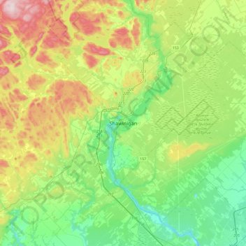
Name: Shawinigan topographic map, elevation, terrain.
Location: Shawinigan, Mauricie, Quebec, G9N 1H2, Canada (46.37966 -72.91186 46.69966 -72.59186)
Average elevation: 456 ft
Minimum elevation: 13 ft
Maximum elevation: 1,358 ft
Other topographic maps
Click on a map to view its topography, its elevation and its terrain.
Lac Français
Canada > Quebec > Shawinigan
Lac Français, Shawinigan, Mauricie, Quebec, Canada
Average elevation: 755 ft