
Moundsville topographic map
Interactive map
Click on the map to display elevation.
About this map
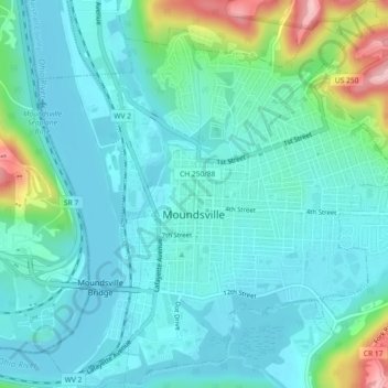
Name: Moundsville topographic map, elevation, terrain.
Average elevation: 725 ft
Minimum elevation: 607 ft
Maximum elevation: 1,207 ft
Other topographic maps
Click on a map to view its topography, its elevation and its terrain.
Pleasant Valley
United States > West Virginia > Marshall County
Pleasant Valley, Marshall County, West Virginia, United States
Average elevation: 1,217 ft
McMechen
United States > West Virginia > Marshall County
McMechen, Marshall County, West Virginia, 26040, United States
Average elevation: 860 ft
Limestone
United States > West Virginia > Marshall County
Limestone, Marshall County, West Virginia, United States
Average elevation: 1,227 ft