
Monte Alegre topographic map
Interactive map
Click on the map to display elevation.
About this map
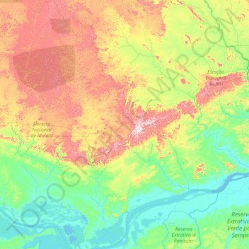
Name: Monte Alegre topographic map, elevation, terrain.
Average elevation: 646 ft
Minimum elevation: -10 ft
Maximum elevation: 2,713 ft
Other topographic maps
Click on a map to view its topography, its elevation and its terrain.
Rio Maicuru
Brazil > Pará > Monte Alegre
Rio Maicuru, Monte Alegre, Microrregião de Santarém, Mesorregião Baixo Amazonas, Pará, North Region, Brazil
Average elevation: 1,053 ft