
Idlewood topographic map
Interactive map
Click on the map to display elevation.
About this map
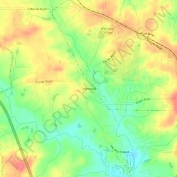
Name: Idlewood topographic map, elevation, terrain.
Location: Idlewood, Macon, Bibb County, Georgia, 31210, United States (32.84153 -83.74185 32.88153 -83.70185)
Average elevation: 433 ft
Minimum elevation: 325 ft
Maximum elevation: 531 ft
Other topographic maps
Click on a map to view its topography, its elevation and its terrain.
Heritage Acres
United States > Georgia > Bibb County > Macon
Heritage Acres, Macon, Bibb County, Georgia, 31211, United States
Average elevation: 390 ft
Sofkee
United States > Georgia > Bibb County > Macon
Sofkee, Macon, Bibb County, Georgia, 31297, United States
Average elevation: 361 ft
Avondale
United States > Georgia > Bibb County > Macon
Avondale, Macon, Bibb County, Georgia, 31297, United States
Average elevation: 322 ft
Wood Valley
United States > Georgia > Bibb County > Macon
Wood Valley, Macon, Bibb County, Georgia, 31211, United States
Average elevation: 394 ft
Christophers Cove
United States > Georgia > Bibb County > Macon
Christophers Cove, Macon, Bibb County, Georgia, 31220, United States
Average elevation: 427 ft
Lake Arrowhead
United States > Georgia > Bibb County > Macon
Lake Arrowhead, Macon, Bibb County, Georgia, 31217, United States
Average elevation: 449 ft
Lizella
United States > Georgia > Bibb County > Macon > Lizella
Lizella, Macon, Bibb County, Georgia, 31052, United States
Average elevation: 479 ft
Ocmulgee Mounds National Historical Park
United States > Georgia > Bibb County > Macon
Ocmulgee Mounds National Historical Park, Short Circle, Macon, Bibb County, Georgia, 31201-1662, United States
Average elevation: 315 ft