
Morro Reuter topographic map
Interactive map
Click on the map to display elevation.
About this map
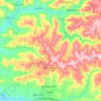
Name: Morro Reuter topographic map, elevation, terrain.
Average elevation: 1,138 ft
Minimum elevation: 72 ft
Maximum elevation: 2,513 ft
Other topographic maps
Click on a map to view its topography, its elevation and its terrain.
Morro Reuter
Brazil > Rio Grande do Sul > Morro Reuter
Morro Reuter, Região Geográfica Imediata de Novo Hamburgo - São Leopoldo, Região Geográfica Intermediária de Porto Alegre, Rio Grande do Sul, South Region, 93990-000, Brazil
Average elevation: 1,319 ft