
Ancient Olympia topographic map
Interactive map
Click on the map to display elevation.
About this map
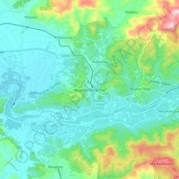
Name: Ancient Olympia topographic map, elevation, terrain.
Average elevation: 325 ft
Minimum elevation: 13 ft
Maximum elevation: 1,345 ft
Another location that has a special interest to both ancients and moderns is the stadium. It is basically a field with start and end lines marked off by transverse curbing. The athletes entered under an archway of a vaulted corridor at the start. Spectators sat mainly on the field's sloping flanks. The length of this field became the standard stadion, an ancient Greek unit of distance, which appears in all the geographers. The stadium has been resurrected for Olympic use with no intentional alteration of the ancient topography. Transient stands are easily thrown up and removed.
Other topographic maps
Click on a map to view its topography, its elevation and its terrain.
Zacharo
Greece > Peloponnese, Western Greece and the Ionian > Elis Regional Unit > Zacharo Municipal Unit
Zacharo, Zacharo Municipal Unit, Municipality of Zacharo, Elis Regional Unit, Western Greece, Peloponnese, Western Greece and the Ionian, 270 54, Greece
Average elevation: 279 ft
Olympia
Greece > Peloponnese, Western Greece and the Ionian > Elis Regional Unit > Ancient Olympia
Olympia, Ancient Olympia, Municipality of Ancient Olympia, Elis Regional Unit, Western Greece, Peloponnese, Western Greece and the Ionian, 27065, Greece
Average elevation: 187 ft
Agios Nikolaos
Greece > Peloponnese, Western Greece and the Ionian > Elis Regional Unit > Zacharo > Agios Nikolaos
Agios Nikolaos, Zacharo, Municipality of Zacharo, Elis Regional Unit, Western Greece, Peloponnese, Western Greece and the Ionian, 27054, Greece
Average elevation: 13 ft