
Brookville topographic map
Interactive map
Click on the map to display elevation.
About this map
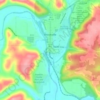
Name: Brookville topographic map, elevation, terrain.
Location: Brookville, Franklin County, Indiana, United States (39.39835 -85.02953 39.43613 -84.99371)
Average elevation: 748 ft
Minimum elevation: 587 ft
Maximum elevation: 974 ft
Other topographic maps
Click on a map to view its topography, its elevation and its terrain.
Metamora
United States > Indiana > Franklin County
Metamora, Franklin County, Indiana, 47030, United States
Average elevation: 794 ft
Oldenburg
United States > Indiana > Franklin County
Oldenburg, Franklin County, Indiana, United States
Average elevation: 945 ft
Hamburg
United States > Indiana > Franklin County
Hamburg, Franklin County, Indiana, 47036, United States
Average elevation: 899 ft
Peppertown
United States > Indiana > Franklin County
Peppertown, Franklin County, Indiana, 47030, United States
Average elevation: 925 ft
Andersonville
United States > Indiana > Franklin County
Andersonville, Franklin County, Indiana, United States
Average elevation: 1,040 ft
Laurel
United States > Indiana > Franklin County
Laurel, Franklin County, Indiana, United States
Average elevation: 787 ft
New Trenton
United States > Indiana > Franklin County
New Trenton, Franklin County, Indiana, 47035, United States
Average elevation: 755 ft
Bath
United States > Indiana > Franklin County
Bath, Franklin County, Indiana, 47010, United States
Average elevation: 1,024 ft
Cedar Grove
United States > Indiana > Franklin County
Cedar Grove, Franklin County, Indiana, United States
Average elevation: 755 ft
Scipio
United States > Indiana > Franklin County
Scipio, Franklin County, Indiana, United States
Average elevation: 896 ft
Mount Carmel
United States > Indiana > Franklin County
Mount Carmel, Franklin County, Indiana, United States
Average elevation: 1,007 ft
Blooming Grove
United States > Indiana > Franklin County
Blooming Grove, Franklin County, Indiana, United States
Average elevation: 981 ft
Lake View
United States > Indiana > Franklin County
Lake View, Franklin County, Indiana, United States
Average elevation: 988 ft
Sharptown
United States > Indiana > Franklin County
Sharptown, Franklin County, Indiana, 47016, United States
Average elevation: 978 ft