
Rosewell topographic map
Interactive map
Click on the map to display elevation.
About this map
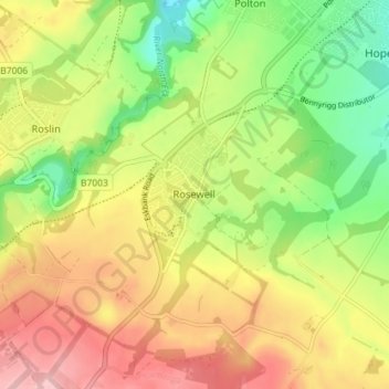
Name: Rosewell topographic map, elevation, terrain.
Location: Rosewell, Midlothian, Scotland, EH24 9AA, United Kingdom (55.83058 -3.15736 55.87058 -3.11736)
Average elevation: 499 ft
Minimum elevation: 246 ft
Maximum elevation: 761 ft
Other topographic maps
Click on a map to view its topography, its elevation and its terrain.
Castlelaw
United Kingdom > Scotland > Midlothian
Castlelaw, Midlothian, Scotland, EH26 0PB, United Kingdom
Average elevation: 889 ft
Dryden Farm
United Kingdom > Scotland > Midlothian > Loanhead
Dryden Farm, Loanhead, Midlothian, Scotland, EH25 9PS, United Kingdom
Average elevation: 472 ft
Bilston
United Kingdom > Scotland > Midlothian
Bilston, Midlothian, Scotland, EH25 9SH, United Kingdom
Average elevation: 554 ft
Loanhead
United Kingdom > Scotland > Midlothian
Loanhead, Midlothian, Scotland, EH20 9RG, United Kingdom
Average elevation: 436 ft
Bonnyrigg
United Kingdom > Scotland > Midlothian
Bonnyrigg, Midlothian, Scotland, EH19 2DA, United Kingdom
Average elevation: 374 ft