
临沂市 topographic map
Interactive map
Click on the map to display elevation.
About this map
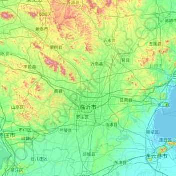
Name: 临沂市 topographic map, elevation, terrain.
Location: 临沂市, 山东省, 中国 (34.37858 117.41112 36.20173 119.19511)
Average elevation: 459 ft
Minimum elevation: -7 ft
Maximum elevation: 3,474 ft
Other topographic maps
Click on a map to view its topography, its elevation and its terrain.
昌邑市城市规划技术服务中心潍河西开放式养殖项目
昌邑市城市规划技术服务中心潍河西开放式养殖项目, 昌邑市, 潍坊市, 山东省, 中国
Average elevation: 0 ft