
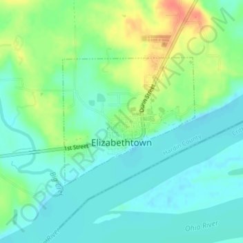
Elizabethtown topographic map
Interactive map
Click on the map to display elevation.
About this map
Name: Elizabethtown topographic map, elevation, terrain.
Location: Elizabethtown, Hardin County, Illinois, United States (37.44109 -88.31334 37.45534 -88.29484)
Average elevation: 371 ft
Minimum elevation: 318 ft
Maximum elevation: 482 ft
Other topographic maps
Click on a map to view its topography, its elevation and its terrain.
Cave In Rock State Park
United States > Illinois > Hardin County > Cave-In-Rock > Cave-in-Rock
Cave In Rock State Park, Clay Street, Cave-in-Rock, Cave-In-Rock, Hardin County, Illinois, 62919, United States
Average elevation: 381 ft