
Skopelos topographic map
Interactive map
Click on the map to display elevation.
About this map
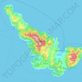
Name: Skopelos topographic map, elevation, terrain.
Average elevation: 194 ft
Minimum elevation: -3 ft
Maximum elevation: 2,159 ft
The second largest settlement is Glossa village, situated on the northwestern tip of the island, just above Loutraki harbour, with an elevation ranging from 200 to 300 m (656 to 984 ft). It is 25.4 km (15.8 mi) from Skopelos town. It is a tranquil village with traditional houses, with 993 residents.