
Monroe topographic map
Interactive map
Click on the map to display elevation.
About this map
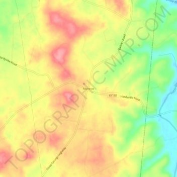
Name: Monroe topographic map, elevation, terrain.
Location: Monroe, Hart County, Kentucky, 42746, United States (37.21228 -85.71775 37.25228 -85.67775)
Average elevation: 689 ft
Minimum elevation: 505 ft
Maximum elevation: 827 ft
Other topographic maps
Click on a map to view its topography, its elevation and its terrain.
Lone Star
United States > Kentucky > Hart County
Lone Star, Hart County, Kentucky, 42713, United States
Average elevation: 748 ft
Uno
United States > Kentucky > Hart County
Uno, Hart County, Kentucky, United States
Average elevation: 659 ft
Hardyville
United States > Kentucky > Hart County
Hardyville, Hart County, Kentucky, United States
Average elevation: 696 ft
Jonesville
United States > Kentucky > Hart County
Jonesville, Hart County, Kentucky, 42757, United States
Average elevation: 791 ft
Canmer
United States > Kentucky > Hart County
Canmer, Hart County, Kentucky, United States
Average elevation: 607 ft
Big Windy
United States > Kentucky > Hart County
Big Windy, Hart County, Kentucky, 42729, United States
Average elevation: 676 ft
Bee
United States > Kentucky > Hart County
Bee, Hart County, Kentucky, 42729, United States
Average elevation: 755 ft
Hammonville
United States > Kentucky > Hart County
Hammonville, Hart County, Kentucky, United States
Average elevation: 761 ft
Northtown
United States > Kentucky > Hart County
Northtown, Hart County, Kentucky, United States
Average elevation: 738 ft
Woodsonville
United States > Kentucky > Hart County
Woodsonville, Hart County, Kentucky, 42765, United States
Average elevation: 600 ft
Munfordville
United States > Kentucky > Hart County
Munfordville, Hart County, Kentucky, United States
Average elevation: 627 ft
Kessinger
United States > Kentucky > Hart County
Kessinger, Hart County, Kentucky, 42765, United States
Average elevation: 853 ft
Rowletts
United States > Kentucky > Hart County
Rowletts, Hart County, Kentucky, United States
Average elevation: 646 ft
Horse Cave
United States > Kentucky > Hart County
Horse Cave, Hart County, Kentucky, United States
Average elevation: 679 ft
Bonnieville
United States > Kentucky > Hart County
Bonnieville, Hart County, Kentucky, 42713, United States
Average elevation: 696 ft
Cub Run
United States > Kentucky > Hart County
Cub Run, Hart County, Kentucky, 42729, United States
Average elevation: 738 ft