
Shouf Cedar Biosphere Reserve Limit topographic map
Interactive map
Click on the map to display elevation.
About this map
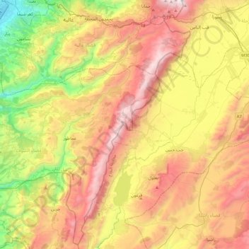
Name: Shouf Cedar Biosphere Reserve Limit topographic map, elevation, terrain.
Average elevation: 3,215 ft
Minimum elevation: 30 ft
Maximum elevation: 6,752 ft
Other topographic maps
Click on a map to view its topography, its elevation and its terrain.
Mrayjat
Mrayjat, Zahlé District, Beqaa Governorate, 1802, Lebanon
Average elevation: 3,750 ft
Kfar Mishki
Kfar Mishki, Rashayya District, Beqaa Governorate, Lebanon
Average elevation: 3,422 ft
Anjar
Anjar, Zahlé District, Beqaa Governorate, Lebanon
Average elevation: 3,107 ft
Saghbine
Saghbine, Western Beqaa District, Beqaa Governorate, Lebanon
Average elevation: 3,658 ft
Mashghara
Mashghara, Western Beqaa District, Beqaa Governorate, Lebanon
Average elevation: 3,596 ft
Western Beqaa District
Western Beqaa District, Beqaa Governorate, Lebanon
Average elevation: 3,579 ft
Rashaya
Lebanon > Beqaa Governorate > Rashaya
Rashaya, Rashayya District, Beqaa Governorate, Lebanon
Average elevation: 3,855 ft
Tall Znoub
Lebanon > Beqaa Governorate > Tall Znoub
Tall Znoub, Western Beqaa District, Beqaa Governorate, Lebanon
Average elevation: 2,884 ft
Fourzol
Lebanon > Beqaa Governorate > Fourzol
Fourzol, Zahlé District, Beqaa Governorate, Lebanon
Average elevation: 3,524 ft
Zahle
Zahle, Zahlé District, Beqaa Governorate, 1801, Lebanon
Average elevation: 4,203 ft