
Petit Jean Mountain topographic map
Interactive map
Click on the map to display elevation.
About this map
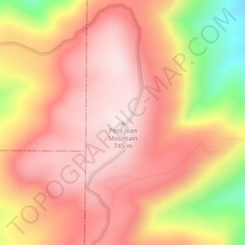
Name: Petit Jean Mountain topographic map, elevation, terrain.
Location: Petit Jean Mountain, Yell County, Arkansas, United States (35.02282 -93.69997 35.02292 -93.69987)
Average elevation: 1,962 ft
Minimum elevation: 1,001 ft
Maximum elevation: 2,431 ft
Other topographic maps
Click on a map to view its topography, its elevation and its terrain.
Petit Jean River State Wildlife Management Area
United States > Arkansas > Yell County
Petit Jean River State Wildlife Management Area, Yell County, Arkansas, 72829, United States
Average elevation: 315 ft
Rover
United States > Arkansas > Yell County
Rover, Yell County, Arkansas, 72860, United States
Average elevation: 407 ft
Belleville
United States > Arkansas > Yell County
Belleville, Yell County, Arkansas, 72824, United States
Average elevation: 394 ft
Mount Nebo
United States > Arkansas > Yell County
Mount Nebo, Yell County, Arkansas, United States
Average elevation: 1,152 ft
Dardanelle
United States > Arkansas > Yell County
Dardanelle, Yell County, Arkansas, 72834, United States
Average elevation: 348 ft
Ola
United States > Arkansas > Yell County > Ola > Ola
Ola, Yell County, Arkansas, 72853, United States
Average elevation: 397 ft