
Eyjafjallajökull topographic map
Interactive map
Click on the map to display elevation.
About this map
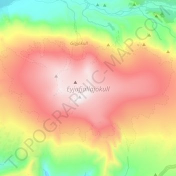
Name: Eyjafjallajökull topographic map, elevation, terrain.
Average elevation: 2,694 ft
Minimum elevation: 358 ft
Maximum elevation: 5,341 ft
Eyjafjallajökull (Icelandic: (listen); lit. 'glacier of the mountains of the islands') is one of the smaller ice caps of Iceland, north of Skógar and west of Mýrdalsjökull. The ice cap covers the caldera of a volcano with a summit elevation of 1,651 metres (5,417 ft). The volcano has erupted relatively frequently since the Last Glacial Period, most recently in 2010, when, although relatively small for a volcanic eruption, it caused enormous disruption to air travel across western and northern Europe for a week.
Other topographic maps
Click on a map to view its topography, its elevation and its terrain.
Eyjafjallajökull
Eyjafjallajökull, Rangárþing eystra, Southern Region, Iceland
Average elevation: 4,787 ft
Skogafoss
Skogafoss, Rangárþing eystra, Southern Region, Iceland
Average elevation: 476 ft
Eyjafjallajökul
Eyjafjallajökul, Rangárþing eystra, Southern Region, Iceland
Average elevation: 4,928 ft