
Campobasso topographic map
Interactive map
Click on the map to display elevation.
About this map
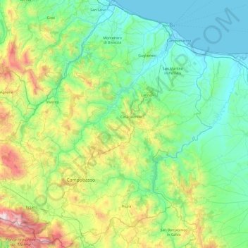
Name: Campobasso topographic map, elevation, terrain.
Location: Campobasso, Molise, Italy (41.36406 14.37773 42.07028 15.16168)
Average elevation: 1,427 ft
Minimum elevation: -3 ft
Maximum elevation: 6,608 ft
Other topographic maps
Click on a map to view its topography, its elevation and its terrain.
San Martino in Pensilis
Italy > Molise > Campobasso
San Martino in Pensilis, Campobasso, Molise, Italy
Average elevation: 453 ft
Roccamandolfi
Roccamandolfi, Isernia, Molise, Italy
Average elevation: 3,783 ft
Pietrabbondante
Pietrabbondante, Isernia, Molise, Italy
Average elevation: 2,825 ft
Monte Vairano
Monte Vairano, Baranello, Campobasso, Molise, Italy
Average elevation: 2,575 ft
Pietracatella
Italy > Molise > Pietracatella
Pietracatella, Campobasso, Molise, Italy
Average elevation: 1,463 ft