
Volos Municipality topographic map
Interactive map
Click on the map to display elevation.
About this map
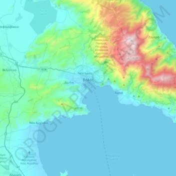
Name: Volos Municipality topographic map, elevation, terrain.
Average elevation: 748 ft
Minimum elevation: -10 ft
Maximum elevation: 5,262 ft
Other topographic maps
Click on a map to view its topography, its elevation and its terrain.
Makrinitsa
Greece > Thessaly and Central Greece > Regional Unit of Magnesia > Volos Municipality
Makrinitsa, Volos Municipality, Regional Unit of Magnesia, Thessaly, Thessaly and Central Greece, 370 11, Greece
Average elevation: 2,175 ft
Agios Ioannis
Greece > Thessaly and Central Greece > Regional Unit of Magnesia > Volos Municipality > Portaria
Agios Ioannis, Portaria, Volos Municipality, Regional Unit of Magnesia, Thessaly, Thessaly and Central Greece, 370 11, Greece
Average elevation: 2,674 ft
Ano Volos
Greece > Thessaly and Central Greece > Regional Unit of Magnesia > Volos Municipality
Ano Volos, Volos Municipality, Regional Unit of Magnesia, Thessaly, Thessaly and Central Greece, 385 00, Greece
Average elevation: 948 ft