
Gordonsville topographic map
Interactive map
Click on the map to display elevation.
About this map
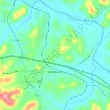
Name: Gordonsville topographic map, elevation, terrain.
Average elevation: 571 ft
Minimum elevation: 453 ft
Maximum elevation: 928 ft
Other topographic maps
Click on a map to view its topography, its elevation and its terrain.
Pleasant Shade
United States > Tennessee > Smith County
Pleasant Shade, Smith County, Middle Tennessee, Tennessee, United States
Average elevation: 709 ft
South Carthage
United States > Tennessee > Smith County
South Carthage, Smith County, Tennessee, United States
Average elevation: 574 ft
Carthage
United States > Tennessee > Smith County > Carthage > Carthage
Carthage, Smith County, Tennessee, 37030, United States
Average elevation: 600 ft
Chestnut Mound
United States > Tennessee > Smith County > Chestnut Mound
Chestnut Mound, Smith County, Tennessee, 38552, United States
Average elevation: 853 ft
Elmwood
United States > Tennessee > Smith County > Elmwood
Elmwood, Smith County, Tennessee, 38560, United States
Average elevation: 692 ft