
榆林市 topographic map
Interactive map
Click on the map to display elevation.
About this map
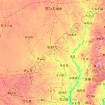
Name: 榆林市 topographic map, elevation, terrain.
Location: 榆林市, 陕西省, 中国 (36.81537 107.25112 39.58494 111.24248)
Average elevation: 4,170 ft
Minimum elevation: 1,995 ft
Maximum elevation: 8,990 ft
地貌以长城为界,长城以北为风沙草滩区,约占辖区总面积的43%,以南为黄土丘陵沟壑区,约占辖区总面积的57%。在地质的构造单元上属于华北地台的鄂尔多斯台斜、陕北台凹的中北部。其东北部靠近东胜台凸,历史上未见岩浆岩生成和岩浆活动,极少见地震。总体地势由西部向东倾斜,西南部平均海拔1600--1800米,其他各地平均海拔1000--1200米。市区内最高处为定边县南部的魏梁,海拔1907米,最低处是清涧无定河入黄河口,海拔560米。地貌分为风沙草滩区、黄土丘陵沟壑区、梁状低山丘陵区三大类。
Other topographic maps
Click on a map to view its topography, its elevation and its terrain.