
Cannock topographic map
Interactive map
Click on the map to display elevation.
About this map
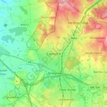
Name: Cannock topographic map, elevation, terrain.
Average elevation: 476 ft
Minimum elevation: 295 ft
Maximum elevation: 784 ft
Other topographic maps
Click on a map to view its topography, its elevation and its terrain.
Hednesford Hills
United Kingdom > England > Staffordshire > Cannock Chase
Hednesford Hills, Cannock Chase, Staffordshire, England, WS12 1BF, United Kingdom
Average elevation: 636 ft
Brereton
United Kingdom > England > Staffordshire > Cannock Chase
Brereton, Cannock Chase, Staffordshire, England, WS15 1HH, United Kingdom
Average elevation: 348 ft
Hednesford
United Kingdom > England > Staffordshire > Cannock Chase
Hednesford, Cannock Chase, Staffordshire, England, United Kingdom
Average elevation: 607 ft
Rugeley
United Kingdom > England > Staffordshire > Cannock Chase
Rugeley, Cannock Chase, Staffordshire, England, United Kingdom
Average elevation: 295 ft
Cannock Wood
United Kingdom > England > Staffordshire > Cannock Chase
Cannock Wood, Cannock Chase, Staffordshire, England, United Kingdom
Average elevation: 630 ft
Norton Canes
United Kingdom > England > Staffordshire > Cannock Chase
Norton Canes, Cannock Chase, Staffordshire, England, WS11 9RE, United Kingdom
Average elevation: 518 ft