
Shelbyville topographic map
Interactive map
Click on the map to display elevation.
About this map
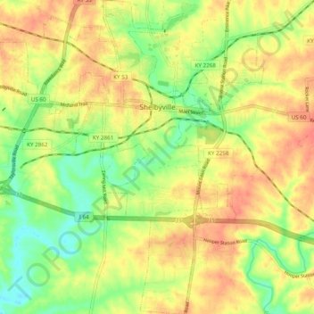
Name: Shelbyville topographic map, elevation, terrain.
Location: Shelbyville, Shelby County, Kentucky, 40065, United States (38.16190 -85.28269 38.23769 -85.19094)
Average elevation: 761 ft
Minimum elevation: 659 ft
Maximum elevation: 846 ft
Other topographic maps
Click on a map to view its topography, its elevation and its terrain.
Jeptha Knob
United States > Kentucky > Shelby County
Jeptha Knob, Shelby County, Kentucky, United States
Average elevation: 971 ft
Shelbyville
United States > Kentucky > Shelby County > Shelbyville
Shelbyville, Shelby County, Kentucky, 40065, United States
Average elevation: 768 ft